On the frozen edge of the Barents Sea, the noise hits you first.
The crack and groan of sea ice breaking up weeks ahead of schedule, the low roar of gray water where locals say there should still be a solid white bridge. A group of scientists stands on the shore, not talking much, watching a polar bear pacing along a ragged ice floe the size of a supermarket parking lot. The bear looks small against the dark water. A drone hums overhead, mapping the chaos. On their tablets, air pressure curves and temperature spikes dance in real time.
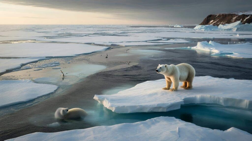
They’re watching an early February Arctic that no longer behaves like February at all.
Arctic February that feels like April
Meteorologists across the Northern Hemisphere are sounding unusually nervous about the coming days. An abrupt surge of warm, moist air is forecast to punch into the high Arctic, pushing temperatures up to 20°C above the seasonal norm in some regions. That doesn’t mean T‑shirt weather at the North Pole, but it does mean air hovering dangerously close to freezing in places that should be locked well below zero.

For sea ice, that’s the difference between resting quietly and starting to rot from within.
We’ve already had a taste of this new normal. In early February 2020, the northern tip of Greenland briefly flirted with temperatures near 0°C while a storm hurled Atlantic heat straight into the polar night. Satellite images showed a bizarre scene: open water patches where, on paper, there should have been thick, multi‑year ice.
Biologists later reported ringed seals abandoning traditional breeding sites. Snow dens collapsed or flooded, pups exposed to freezing rain they weren’t built for. That year, an Inuit hunter from Qaanaaq described arriving at a “trusted” ice route and finding it thin and glassy, as if someone had swapped winter for a late spring overnight.
This incoming early‑February anomaly looks uncomfortably similar. Warm air rides north on a disrupted jet stream, pushed by stubborn high‑pressure domes over Eurasia and the North Atlantic. As the stratospheric polar vortex wobbles and stretches, the Arctic’s “cold lock” weakens, letting heat sneak in from lower latitudes.
The physics are brutally simple. Thin ice plus warm air plus stronger waves equals broken habitat. *Species already squeezed by shrinking ice seasons suddenly lose another critical week, sometimes two, from the calendar they’ve followed for thousands of years.*
Species on a shrinking calendar
From a distance, polar bears dominate the headlines, but they’re only the most photogenic tip of the problem. Early February is a quiet, crucial window for many Arctic and sub‑Arctic animals: a time to give birth, conserve energy, or complete long journeys over safe ice. When a sudden warm surge crashes into that window, it’s not just comfort that’s at stake. It’s timing.
Ecologists talk about “phenological mismatch” — a fancy term for being at the right place at the wrong time.
Take the little‑known but wildly resilient Arctic cod. This small fish thrives in water just above the freezing point and uses sea ice as a nursery. Under the ice, algae bloom in a protected layer, feeding tiny crustaceans, which then feed the cod. When warm air melts or fractures the ice in February, that hidden factory falls apart.
In a 2022 study off Svalbard, scientists found that a single major warm spell slashed ice‑algae productivity by nearly 60%. That ripple moved up the chain: fewer cod, thinner seals, more desperate bears spending energy roaming on unstable floes. One pulse of warmth cascaded through an entire food web like a single bad harvest year for a farming town.

This year’s anomaly also threatens seabirds already on the edge. Thick‑billed murres and kittiwakes time their feeding trips around predictable ice edges and cold‑water upwellings. When the ocean surface warms early and mixes differently, the plankton communities shift, and “dinner” moves somewhere else.
Let’s be honest: nobody really tracks this bar‑by‑bar on a home weather app. Yet for these birds, one or two failed breeding seasons in a row can tip a population into long‑term decline. **An early February that feels like late March doesn’t give them a chance to adjust their instincts fast enough.**
What scientists and communities do when the ice misbehaves
So what actually happens in the field when the forecast flashes red for an Arctic heat spike? At the Tromsø forecasting center, meteorologists quietly shift into emergency‑mode routines. They refine models every few hours, cross‑checking satellite data, buoy readings, and aircraft observations over the North Atlantic.
They flag regions where sea ice is most vulnerable — thin, fractured, under attack from warm currents below as well as warm air above — and send targeted alerts to field stations, ship captains, and Indigenous councils that still rely on over‑ice travel.
On the ground, the work gets very practical, very fast. Researchers postpone long snowmobile trips out onto sea ice transects. Hunters in northern Alaska share near‑real‑time updates via radio or WhatsApp groups, warning others where cracks and leads have opened in what used to be trusted zones.
Meteorologists now often translate their technical forecasts into simple, navigational language: “Avoid this bay for the next 72 hours,” or “Use land routes only between these villages.” It’s not a perfect system, and yes, some days the models miss. But **those small, tactical decisions can be the difference between a safe season and a tragedy**.
For conservation teams, early February anomalies have become a trigger for what they call “rapid adjustment protocols.” They might increase aerial monitoring of key breeding areas or temporarily shift human activity away from stressed wildlife. One Arctic marine biologist described the mindset as “field triage”.
“We used to plan our season around the calendar,” says Dr. Lena Mikkelsen, who studies ice‑dependent seals. “Now we plan around anomalies. The calendar is just a suggestion.”
- Move research and tourism off sensitive ice corridors when warm surges are forecast.
- Prioritize protection of key feeding hotspots instead of trying to “save everything everywhere.”
- Channel funding into flexible, mobile monitoring gear that can be redeployed as conditions swing.
- Support Indigenous ice‑safety networks that spread localized knowledge faster than any formal alert.
A fragile frontier the rest of the world feels too
An Arctic warm spell in early February can sound like a remote curiosity, a strange headline from a place most of us will never visit. Yet those distorted temperature maps, all red and orange at the top of the globe, are not just local weather drama. They hint at a climate system shifting under our feet. The same warped jet stream that funnels Atlantic heat into the Arctic can later yank polar air down over Europe or North America, bringing late blizzards, crop damage, power failures.
What happens on the ice does not stay on the ice.
| Key point | Detail | Value for the reader |
|---|---|---|
| Arctic anomalies are getting earlier and stronger | February heat spikes now push temperatures up to 15–20°C above normal in some regions | Helps you understand why “weird winter weather” headlines keep coming |
| Species are locked into ancient calendars | Seals, cod, seabirds and bears can’t instantly retune breeding and feeding to random warm pulses | Makes the crisis feel concrete, not abstract, by linking it to real animals |
| Local response already blends science and tradition | Meteorologists, Indigenous hunters and biologists share ice intelligence in near real time | Shows that adaptation is possible and highlights approaches worth supporting |
FAQ:
- Question 1What exactly is an “Arctic anomaly” in early February?
- Question 2Why are these warm surges so dangerous for polar bears and seals?
- Question 3Do these events affect weather where I live, thousands of kilometers away?
- Question 4Is this just natural variability, or clearly linked to human‑driven climate change?
- Question 5What can an ordinary person do beyond reading worrying headlines?