The first alerts dropped into people’s feeds like any other push notification: “Rare February Arctic breakdown imminent.” Most of us were stirring coffee, wrestling kids into coats, or scrolling half-awake on the train. Nothing unusual there. Just another weather headline in a winter that already feels stranger than the last.
Then the maps started circulating. Vortex graphics, blood-red anomaly blobs stretching down from the pole, breathless TikToks of meteorologists pointing at Europe and the US with a worried crease between their eyebrows. Some called it “a once-in-a-decade pattern shift.” Others, more bluntly, warned of a “weather whiplash event.”
Cue the backlash. Climate skeptics rolled their eyes, talk-radio hosts spoke of “fear porn,” and comment sections lit up with accusations: “Here we go again, another panic.”

Somewhere between those maps and those eye-rolls, a deeper story is unfolding.
When winter suddenly turns upside down
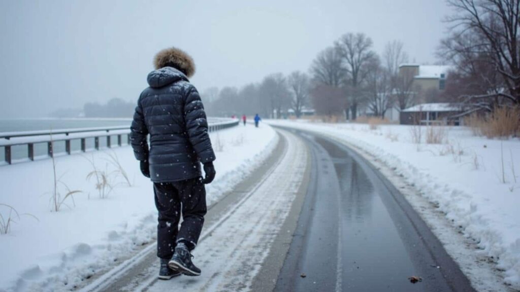
Imagine this: it’s early February, the kind of gray, forgettable day that usually slides quietly through the calendar. You step outside and the air feels… wrong. Not just cold. Sharp. Edgy. A biting wind that wasn’t in yesterday’s forecast.
Later that day you open social media and see the phrase **“Arctic breakdown”** under a screenshot of swirling jet stream lines. A TV meteorologist is leaning into the camera, talking about “polar air spilling south” and “record temperature contrasts.” The studio graphics make your country look like it’s being swallowed by a blue-white wave.
You’re left with the same prickling sense you get when the group chat starts pinging during a breaking news story. Something’s off, and nobody is fully in control.
For meteorologists, this “rare February Arctic breakdown” isn’t a cinematic term. It’s their shorthand for a pattern where the usually tight, spinning pool of frigid air over the North Pole starts wobbling, cracking, and pushing south. The polar vortex, instead of staying politely put, leaks.
In the last decade, we’ve seen versions of this story: Texas freezing in 2021, Europe’s shock cold snaps, freak snowstorms landing on cities that barely own snowplows. The difference this time, they say, is the setup. Oceans that are unusually warm for winter. A jet stream that looks more like a loose rope than a clean belt. Temperature models flashing purple and blue over densely populated regions.
These are not the cartoon exaggerations of a disaster movie. They’re real numbers, pulled from satellites, weather balloons, and ground stations quietly ticking away in the dark.
So why the talk of panic? Because the science and the storytelling don’t always move at the same speed. Researchers write about “weakened polar vortex dynamics” and “increased meandering of the jet stream.” News headlines shorten that to “Arctic breakdown could bring chaos.”
Climate skeptics seize on the tone. They argue that calling this “rare” is misleading when the term pops up every few years in winter coverage. They point to cold spells as proof that global warming is exaggerated. And they question the motives of scientists warning about risk: Are they raising awareness, or building a brand?
The real tension lives in the gap between nuance and urgency. Weather models talk in probabilities. Social feeds demand drama. Caught in the middle is the public, trying to decide whether to buy extra salt, or just scroll on.
 I’ve spent hundreds of hours on long Amtrak rides. Here are my 10 best tips for first-time riders.
Reading the warnings without losing your mind
There is a quieter way to look at a scary map. Start simple. When meteorologists talk about a February Arctic breakdown, they’re usually flagging three things: where the cold might hit, how intense it might be, and how long it might stick. Focus on those basics first.
Look for local detail, not just global drama. A viral map of the whole hemisphere doesn’t tell you if your town will see -5°C or -25°C. Follow your national weather service, a trusted local forecaster, and one or two science-based voices. When they all start circling the same dates and regions, that’s when it’s worth paying attention.
And if a forecast sounds like a movie trailer, pause. Ask: what’s the actual number on the thermometer, and what does that mean for my daily life?
Many people do the opposite. They see the scariest chart first, feel the jolt of anxiety, and tune out right when the useful information arrives. We’ve all been there, that moment when the brain goes “too much” and quietly shuts the door.
Others fall into another trap: mocking every warning as “just hype.” Then a real cold wave hits, pipes burst, roads glaze over, and the same people end up furious that “nobody warned us.” The warnings were there. They just didn’t look dramatic enough at the time.
Let’s be honest: nobody really reads the full forecast discussion every single day. Most of us skim headlines, glance at an app, and move on. That’s why tone matters so much. If everything sounds like panic, nothing stands out when it should.
“Calling this ‘needless panic’ misses the point,” says Dr. Elena R., a climate dynamics researcher who has spent 15 winters staring at polar vortex charts. “We’re not saying the sky is falling. We’re saying the dice are loaded for more extreme swings, and people deserve a heads-up when those swings look likely.”
- What to watch for
Look at temperature anomalies, not just raw numbers. A -8°C day might be normal in one region and shocking in another. Spikes away from your local average matter more than big colors on a global map. - How to separate hype from signal
If a post cites actual model names (like ECMWF or GFS), mentions uncertainty, and avoids guaranteed language, it’s usually more grounded than the “monster storm incoming!!!” type of content. - When to actually act
You don’t need to prep for every scary tweet. Wait until your official national service or a seasoned local forecaster repeats the alert for your area over several updates. That’s your cue to adjust travel, protect pipes, or check on vulnerable neighbors.
A cold snap, a hot debate, and a changing baseline
Behind the noise, one plain fact sits stubbornly on the table: the climate baseline is shifting. The Arctic is warming faster than the rest of the planet, sea ice is thinning, and the “normal” patterns that older forecasters grew up with are quietly rewriting themselves.
That doesn’t mean every February Arctic breakdown is a sign of the apocalypse. Weather is still weather, with its natural swings and surprises. A rare pattern can appear without being brand new. There’s still debate among scientists about exactly how much Arctic warming is tugging on the jet stream, and how often that will bend cold air south.
What’s changing is the context. When the background warmth rises, the contrast grows. Warm oceans feeding storms. Colder bursts feeling sharper against milder winters. *The same kind of breakdown that felt like a fluke in 1980 now lands in a world already stressed by heatwaves, floods, and fire seasons that won’t quit.*
| Key point | Detail | Value for the reader |
|---|---|---|
| Understand “Arctic breakdown” | Refers to disruptions in the polar vortex and jet stream that let Arctic air spill south in unusual ways | Gives context to alarming headlines and helps you judge real risk, not just clickbait |
| Balance skepticism and caution | Question tone and sources, but still act when multiple credible forecasts align on local impacts | Reduces both panic and complacency, helping you prepare only when it’s genuinely useful |
| Watch the shifting baseline | More extreme swings are occurring against a backdrop of overall warming and changing Arctic conditions | Helps you see your own winter not as an isolated “weird year” but as part of a longer trend |
FAQ:
- Is a February Arctic breakdown proof of climate change?
No single event proves climate change. That said, scientists are increasingly studying how a rapidly warming Arctic may be making these breakdowns and jet-stream wobbles more likely or more disruptive.- Why do some people call these warnings “needless panic”?
Because the language around extreme weather can sound dramatic, some skeptics feel scientists and media are exaggerating risk. Many researchers argue they’re simply describing growing uncertainty and potential impacts as clearly as they can.- Can cold waves still happen in a warming world?
Yes. A warmer average climate does not cancel winter. It shifts patterns, raising the overall baseline while still allowing pockets of intense cold, sometimes in places that aren’t used to it.- How should I react to alarming weather headlines?
Take a breath, then cross-check with your national weather service and a trusted local forecaster. If those sources echo the concern for your area over several days, it’s time to adjust plans or take simple precautions.- Are these events going to become more common?
That’s still an active research question. Some studies suggest a link between Arctic warming and more frequent or intense disruptions of the polar vortex; others see a weaker connection. What’s clear is that extreme swings, hot and cold, are no longer rare guests in our seasons.