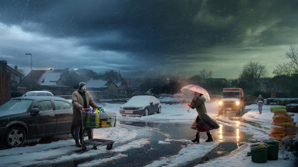
The first flakes started falling while the supermarket loudspeakers were still playing tired January pop songs. Outside, cars crawled past in a blur of headlights and wet snow, wipers beating harder than usual. A dad pushed a trolley loaded with bottled water and pasta, glancing every few seconds at the grey sky. Near the entrance, an elderly woman struggled with a broken umbrella that the wind seemed determined to steal.
Everyone had heard the same name on the radio that morning: Storm Harry. Heavy snow. Ferocious rain. Gusts that could rattle windows and nerves.
By the time the automatic doors slid open again, the snow had already thickened into slush, and the air felt like it was holding its breath.

Something was clearly coming.
Storm Harry: a winter punch of snow, rain and rising anxiety
Storm Harry is not the kind of system you just “ride out” with a cup of tea and a good series. Meteorologists describe it as a complex winter storm, with a dense mix of cold air, moist Atlantic fronts and a jet stream perfectly lined up to throw everything at us at once. Heavy snow for some areas, driving rain for others, and a messy, icy mix for those stuck in between.
The key date lurking in every forecast is the same: intense conditions expected on and off until January 29th.
Across mountain towns and small suburbs, local councils have already started posting the same warning graphics. Blue for snow. Dark green for heavy rain. Angry yellow bands for severe wind. In one northern village, the school car park is already stacked with salt bags and the old orange gritter that only comes out for “proper” weather.
Parents are quietly wondering if classes will stay open. Delivery drivers are checking their routes twice. Rail operators are sending out cautious emails about “possible disruption” and “reduced services”. One train line that crosses a high viaduct has already announced speed limits “due to expected crosswinds and ice”.
Behind the coloured weather maps lies a simple chain reaction. Cold air sliding down from the north collides with moisture-laden clouds from the Atlantic, and Storm Harry feeds on the contrast. Where the cold holds firm, snow settles fast, turning roads into glossy traps. Where milder air nudges in, the snow flips to heavy rain, swelling rivers that are already close to their banks.
That’s why the same storm can shut down one town with thick snow while flooding another just 40 kilometres away. The real story is not just the storm itself, but how differently it will hit each street, each home, each commute.
Staying one step ahead of Harry: small actions that matter
If Storm Harry has one weak point, it’s time. We know roughly when it will peak, and we have a handful of days to prepare before January 29th comes and goes. That window is gold. Think of it as a chance to do the small, boring things that suddenly become huge when the snow is knee-deep or the rain is pounding your front door.

Check gutters and drains while they’re still visible. Move outdoor furniture and bins that could take flight in a gust. Charge power banks, check batteries in torches, and locate that one candle you only think about when the lights flicker.
We’ve all been there, that moment when the forecast was “probably nothing” and suddenly you’re scraping ice off the inside of your car at 6 a.m. A mum in Leeds shared that during the last big storm, she had to walk her kids to school in wet trainers because she hadn’t realised one boot had a split sole. A tiny oversight that turned a routine day into a freezing slog.
This time, people are already thinking differently. Some are pre‑salting driveways, others are topping up fuel or arranging remote work days around the worst of the forecast. These are not panic moves. They’re just quiet acts of respect for a storm that doesn’t really care if you’re “ready” or not.
Let’s be honest: nobody really does this every single day. Most of us stash good intentions in the same place as that unused snow shovel. Yet Storm Harry is a reminder that winter still has teeth, and a little humility goes a long way.
“Storms don’t have to be disasters,” says an emergency planner from a coastal town. “They only turn into that when the weather arrives faster than our common sense.”
- Clear drains, gutters, and balcony outlets before the heavy rain hits.
- Keep a small “stay-put” kit: water, snacks, basic meds, warm layers, phone charger.
- Plan alternative routes for work or school in case your usual road becomes blocked.
- Photograph your home exterior and valuables for insurance, just in case.
- Check on one neighbour who might struggle if the snow or rain gets intense.
After January 29th: what Storm Harry leaves behind
When the last bands of cloud finally slide away and the radar images start to clear, Storm Harry will leave more than snowdrifts and puddles behind. Some will remember the eerie quiet of a white morning, streets muffled to a whisper. Others will talk about a night of hard rain, the kind that drums on windows and makes you count seconds between thunder and flash.
For a few, there may be damage to deal with. A blown fence. A flooded shed. A cancelled trip that never made it past the planning stage. For others, oddly, there may be a strange sense of reset, like the storm forced a pause they didn’t know they needed.
What tends to last longest, though, is not the chaos, but the stories: the neighbour who turned up with a shovel at 7 a.m., the teenager who spent the afternoon pushing stuck cars, the stranger on a train platform sharing a portable charger with three people at once. *Weather has this stubborn way of reminding us that, underneath the forecasts and alerts, we’re all sharing the same sky.*
Storm Harry will come and go by January 29th. The real question is what we’ll carry forward once the maps turn calm and the headlines move on.
| Key point | Detail | Value for the reader |
|---|---|---|
| Storm Harry’s timeline | Heavy snow and rain expected on and off until January 29th | Helps you align travel, work, and family plans with the riskiest days |
| Mixed hazards | Some regions will see deep snow, others intense rain and flooding risk | Encourages you to check local forecasts, not just national headlines |
| Practical preparation | Simple steps like clearing drains, checking gear, and planning alternatives | Reduces stress, disruption, and potential damage when the storm peaks |
FAQ:
- Will Storm Harry affect all regions the same way?Not at all. Higher and colder areas are more likely to see heavy snow and ice, while lower or coastal regions may get mostly heavy rain and strong winds. Local forecasts are your best guide.
- Is travel safe during Storm Harry?That depends on timing and location. Expect delays, cancellations, and tricky driving conditions, especially on untreated roads or exposed routes. If you can avoid non‑essential travel during peak hours of snow or rain, do it.
- Could schools and public services close?Closures are possible in places hit by deep snow, ice, or flooding. Many schools and services announce decisions early in the morning, so keep an eye on official websites and local media.
- What should I have at home while the storm passes?A modest supply is enough: drinking water, some food that doesn’t need cooking, basic medication, warm clothes or blankets, a working torch, batteries, and a way to charge your phone. Think comfort, not bunker.
- When will things start to calm down?Most models currently suggest that the most active phase of Storm Harry will ease around January 29th, though lingering cold, local flooding, or icy patches may continue a little longer in some areas.