On a dusty roadside in Kenya’s Great Rift Valley a group of schoolchildren press their faces against a bus window. Outside the earth opens into a jagged scar. It is a fresh crack that sliced through farmland after heavy rains. A teacher points and tells them half joking that Africa is breaking apart right here. The kids laugh but some keep staring as if the ground itself had whispered a secret. The air smells of soil and diesel. A shepherd calmly guides his goats around the gash in the land as if it has always been there. The truth is wilder than any classroom legend.
Africa’s Slow but Active Continental Divide
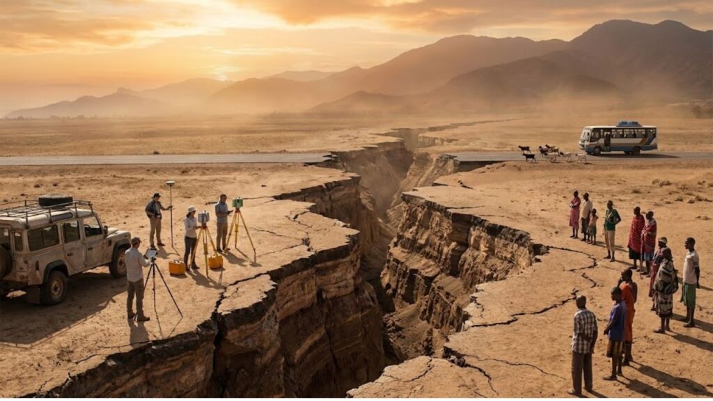
Standing at the edge of the East African Rift creates an unusual feeling. The ground appears stable but the landscape shows clear signs of being torn apart with steep cliffs & long flat valleys and volcanoes visible in the distance. This is a place where the planet’s surface is changing. What is taking place here in extremely slow motion is the start of a continental breakup. Africa is not simply cracking but is stretching and thinning & very gradually separating from itself. In 2018 photographs of a massive crack in southwestern Kenya spread rapidly online. A large trench cut through a road near Mai Mahiu and destroyed the pavement and alarmed drivers. For many people this was the first time the splitting of Africa seemed real rather than just a distant geological concept. Geologists investigated and confirmed that this specific crack was partially created by erosion and heavy rainfall but it is located directly within the larger East African Rift zone. The visible damage on the surface provided a sudden view of a process that has been occurring quietly underground for tens of millions of years. Satellite data now shows with remarkable accuracy that the African continent is already moving. GPS stations fixed into the bedrock demonstrate that parts of East Africa are shifting away from the rest of the continent by a few millimeters each year. That might seem insignificant & easy to dismiss. However when you extend those millimeters over a million years you end up with hundreds of kilometers of separation. The calculations are clear and they indicate this process will lead to a new ocean. The split is no longer just a prediction for some distant future but is a measurable reality happening today in tiny increments.
The Invisible Signs Revealing a Massive Geological Shift
To track a continent splitting apart you need patience & precise equipment. Scientists install metal plates in the ground throughout East Africa and attach GPS antennas on top that connect to satellites orbiting thousands of kilometers above. These receivers record their exact position down to a few millimeters every single day. A clear example exists in Ethiopia’s Afar region which looks almost like another planet. At this location three tectonic plates are separating from one central point to create what scientists call a triple junction. In 2005 a crack stretching 60 kilometers opened within just days as magma pushed upward and the crust pulled apart. Satellites observed the ground dropping and splitting open. Some villages discovered new cracks running through their farmland overnight. Local people found it frightening but geologists saw it as watching a small ocean basin form at high speed. This same rift system continues south through Kenya and Tanzania and further with all of it slowly stretching. What is actually happening beneath the surface? The African tectonic plate is not one solid piece. Underneath East Africa hot rock from deep in the mantle rises up and softens the crust from below. This heat makes the surface bulge and crack and sink. When the continent stretches it becomes thinner like dough being pulled across a table. Over time these cracks grow deeper into complete fractures that fill with magma & seawater. At some point far in the future the split becomes a real boundary and the eastern part of Africa drifts away as its own continent with an ocean separating it from where savannas and cities used to be.

Life Along the Fault Lines of a Future Ocean Basin
The Reality of Living on a Splitting Continent For people who live along the rift the science is very real. Farmers in Kenya and Tanzania already watch the land change as new cracks appear after earthquakes or heavy rains. The methods scientists use to study this movement help governments figure out how to respond. Research teams use GPS data and satellite radar along with ground surveys to map the rift in great detail. This mapping shows where roads and pipelines & power lines need to be built differently or avoided completely. If you live in these areas you will not wake up tomorrow with an ocean view. The splitting happens far too slowly for that. The actual challenge is dealing with an unstable landscape that includes small earthquakes and active volcanoes and ground that slowly sinks over time. Many people think that Africa splitting means disaster is coming soon. This misunderstanding creates fear and dramatic headlines and sometimes hopelessness. Most people do not think about geologic timescales when they see a shocking photo of a giant crack on their phone. A closer look at the data shows there is risk but it is mostly an ongoing situation that can be managed. Scientists who work in these areas describe their work in personal terms. They understand this is not just about geology but about homes & heritage & identity on unstable ground. One Kenyan geologist explained this connection to a reporter. Practical guidance is already being developed. Several basic principles now guide planning discussions in East African countries.

- Key infrastructure should be placed away from the most active faults whenever possible.
- Monitoring networks for volcanoes and earthquakes need funding beyond just major cities.
- Information about rift hazards should be shared clearly in local languages.
- Roads and pipelines should be designed to flex or be moved if the ground cracks.
- Communities need support when their land becomes unsafe instead of being left to manage alone.
A Moving Continent That Reshapes How We View Time
Africa splitting in two sounds like something from a movie but the evidence is right there on the ground. The rift valleys that tourists photograph from their hotels and the volcanoes and lakes that fill the long cracks in the earth are all connected to one slow process. We see dramatic headlines pop up on our phones and forget about them an hour later. This story needs more than a quick glance. It makes us think about time periods that stretch far beyond anything we normally plan for while remembering that real people live in these areas where the ground is actually changing. It challenges us to stop seeing Africa as a fixed shape in an atlas and start understanding it as something that moves & changes. The simple fact is that Africa has not always looked like it does today and it will keep changing. The continents we learn about in school are just temporary arrangements. Millions of years from now people might stand on a completely different coastline and look out at a new ocean covering land where animals graze in the Rift Valley today. The split is happening right now in ways scientists can measure and it is slowly changing the map we assumed would always stay the same.