Researchers writing in the International Journal of Nautical Archaeology discuss several possible uses for the structure. None is certain yet but some ideas stand out. Coastal fish trap: A long wall could have guided fish into enclosed areas at low tide making mass capture easier. Shoreline barrier: It may have worked as a primitive sea defence breaking waves & protecting a settlement or lagoon behind it
7,000-Year-Old Submerged Stone Wall Discovery Challenges Early Human History
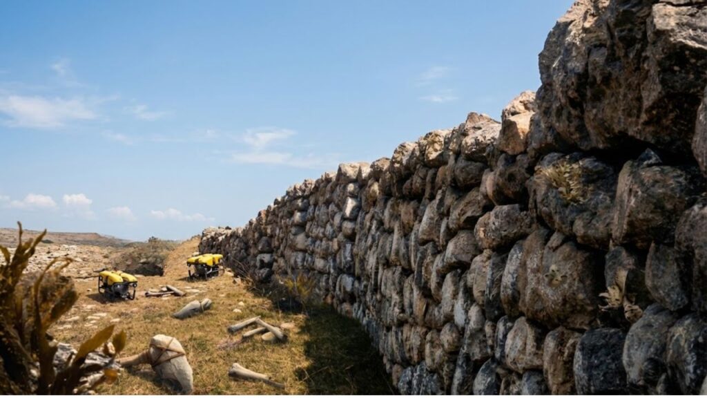
The structure lies off the island of Sein at the western tip of Brittany in waters more familiar to sailors than archaeologists. It first appeared on detailed seafloor maps as a suspiciously straight feature crossing the otherwise rough bottom. French geologist Yves Fouquet noticed the anomaly while examining sonar data. The line seemed too regular and too purposeful to be a random rock ridge. That discovery led to a series of dives between 2022 and 2024. Under about 9 metres of water divers found a clearly human-made monument: a long stone wall built on what was once dry land. On its upper side dozens of granite blocks stand in two nearly parallel rows. These are not small stones scattered by waves. Many weigh several hundred kilos and have been placed in a regular pattern. That arrangement rules out a natural formation and indicates a collective building effort. Radiocarbon and sea-level data place the construction between roughly 5800 and 5300 BC. At that time the shoreline looked very different. Sea level in the region sat about 7 metres lower than today and the island of Sein stretched much farther perhaps fourteen times its current size. The wall was built on dry ground on a low-lying coastal plain. Only centuries later did the Atlantic creep inland and flood the landscape & hide the monument beneath the waves.
A vast ancient stone structure hidden beneath the sea
The structure dates to the end of the Mesolithic period, right before farming began in Brittany. This era was traditionally thought to be dominated by small groups of hunter-gatherers who moved frequently with the seasons and left minimal evidence of their presence. The wall challenges that conventional view. Its considerable length the precise arrangement of its stones and the massive amount of material used indicate that an organized group of workers followed a deliberate design over an extended period that may have lasted months or even years. This degree of coordination conflicts with the traditional picture of loosely organized groups that constantly moved from place to place. It points instead to more permanent settlements along resource-rich coastlines where people could rely on stable fishing areas & return to the same seasonal locations repeatedly.

The underwater wall resting nine metres below today’s shoreline
Researchers writing in the International Journal of Nautical Archaeology discuss several possible uses for the structure. None is certain yet but some ideas stand out.
- Coastal fish trap: A long wall could have guided fish into enclosed areas at low tide making mass capture easier.
- Shoreline barrier: It may have worked as a primitive sea defence breaking waves & protecting a settlement or lagoon behind it.
- Territorial marker: The wall might have marked important access rights to fishing grounds or landing places.
Large stone fish weirs are known from later periods in northern Europe and North America. In those systems walls or fences running across tidal zones pushed fish into traps as the water fell. The newly found Breton wall could be an early version of that same logic built by people who intimately understood tides & currents and seasonal migrations of fish. Another possibility is that communities were already responding to a slowly rising sea. Post-glacial meltwater was still feeding the oceans. Low-lying coasts like western Brittany saw gradual but relentless flooding. A wall along a vulnerable stretch might have slowed erosion or sheltered a lagoon used as a safe harbour for boats.
Evidence of advanced planning by early hunter-gatherer communities
The Reality of Living on a Splitting Continent For people who live along the rift the science is very real. Farmers in Kenya and Tanzania already watch the land change as new cracks appear after earthquakes or heavy rains. The methods scientists use to study this movement help governments figure out how to respond. Research teams use GPS data and satellite radar along with ground surveys to map the rift in great detail. This mapping shows where roads and pipelines & power lines need to be built differently or avoided completely. If you live in these areas you will not wake up tomorrow with an ocean view. The splitting happens far too slowly for that. The actual challenge is dealing with an unstable landscape that includes small earthquakes and active volcanoes and ground that slowly sinks over time. Many people think that Africa splitting means disaster is coming soon. This misunderstanding creates fear and dramatic headlines and sometimes hopelessness. Most people do not think about geologic timescales when they see a shocking photo of a giant crack on their phone. A closer look at the data shows there is risk but it is mostly an ongoing situation that can be managed. Scientists who work in these areas describe their work in personal terms. They understand this is not just about geology but about homes & heritage & identity on unstable ground. One Kenyan geologist explained this connection to a reporter. Practical guidance is already being developed. Several basic principles now guide planning discussions in East African countries.
- Key infrastructure should be placed away from the most active faults whenever possible.
- Monitoring networks for volcanoes and earthquakes need funding beyond just major cities.
- Information about rift hazards should be shared clearly in local languages.
- Roads and pipelines should be designed to flex or be moved if the ground cracks.
- Communities need support when their land becomes unsafe instead of being left to manage alone.
Uncovering the possible purpose behind the mysterious wall
Africa splitting in two sounds like something from a movie but the evidence is right there on the ground. The rift valleys that tourists photograph from their hotels and the volcanoes and lakes that fill the long cracks in the earth are all connected to one slow process. We see dramatic headlines pop up on our phones and forget about them an hour later. This story needs more than a quick glance. It makes us think about time periods that stretch far beyond anything we normally plan for while remembering that real people live in these areas where the ground is actually changing. It challenges us to stop seeing Africa as a fixed shape in an atlas and start understanding it as something that moves & changes. The simple fact is that Africa has not always looked like it does today and it will keep changing. The continents we learn about in school are just temporary arrangements. Millions of years from now people might stand on a completely different coastline and look out at a new ocean covering land where animals graze in the Rift Valley today. The split is happening right now in ways scientists can measure and it is slowly changing the map we assumed would always stay the same.

An ancient coastal landscape lost to rising Atlantic waters
Seven thousand years ago the landscape around Sein looked surprisingly green and open. There were no fields yet but the area had dunes & wetlands and shallow bays filled with shellfish & fish and seabirds. Small groups of people likely traveled between the forested areas inland and the coast as they followed game & gathered resources that changed with the seasons. The sea level continued to rise slowly and those quiet lowlands became mudflats and then eventually turned into seabed. Places where people had lived and made fires and buried their dead & worked all ended up underwater. Most structures made of wood decayed completely & only stone features like this wall remained as evidence. Breton folklore often tells stories about drowned cities and lost lands that once existed beyond the current shoreline. Some archaeologists think these legends might preserve distant memories of real events when people had to retreat from rising water. These retreats happened again and again across many generations and the stories continued long after the original land had vanished beneath the waves.
How a faint sonar signal led to a major prehistoric find
The discovery close to Sein demonstrates that substantial proof of ancient coastal existence remains hidden beyond today’s shoreline. For many years prehistoric studies concentrated mainly on caves and inland flatlands along with megalithic structures such as the well-known standing stones at Carnac. Underwater landscapes presented greater challenges for researchers. They needed sonar equipment and expert divers along with favorable weather conditions. Modern methods have made these previously unreachable areas valuable for learning about early maritime activities & fishing practices as well as how people adjusted to climate changes.
Why underwater archaeology is reshaping our understanding of early societies
The Investigation Process The investigation of the stone wall followed a standard sequence that has become typical in underwater archaeology
| Stage | What Researchers Found |
|---|---|
| Remote Mapping | Detailed bathymetric scans revealed a strikingly straight feature running along the seafloor |
| Focused Dive Surveys | Diving teams examined the site up close, documenting stone placements and recording precise measurements |
| 3D Documentation | Photogrammetry and video footage were used to digitally rebuild the structure once back on land |
| Dating and Analysis | Sea-level data, sediment studies, and regional archaeological evidence were combined to estimate age and purpose |
Scientists today combine geology with archaeology and ocean science in their coastal research work. Every new structure they find and map on the ocean floor adds to our understanding of how ancient people responded to environmental changes thousands of years ago.